Wayne Lumbasi

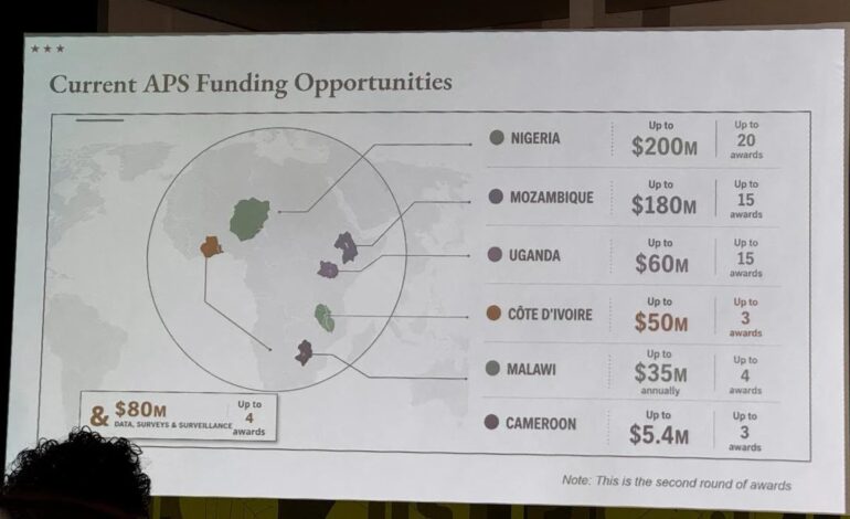
A map of Africa presented by the United States State Department at a major global AIDS conference in Brazil has sparked widespread criticism after several African countries were incorrectly positioned and labelled.
The map was displayed during a presentation at the AIDS 2026 conference in Rio de Janeiro, where U.S. officials were discussing health partnerships, funding and efforts to combat HIV and AIDS across Africa.

The graphic contained several glaring geographical errors. Nigeria, one of Africa’s largest countries, was placed far north of its actual location and was depicted without its coastline along the Gulf of Guinea.

Mozambique, which is located on Africa’s southeastern coast along the Indian Ocean, was instead shown close to the Horn of Africa. Côte d’Ivoire, a West African country, was also positioned in the wrong part of the continent.

Other countries, including Malawi and Uganda, were shown with inaccurate shapes and borders, while Cameroon was also incorrectly represented.
The map drew particular attention because it was presented during an international conference attended by health officials, researchers, advocates and representatives from countries across the world.

Adding to the controversy, the map appeared to carry an OpenAI related watermark, prompting questions about whether artificial intelligence had been used in preparing the presentation.
However, the U.S. State Department did not explicitly confirm that artificial intelligence generated the map.
Instead, a department spokesperson said a team member had made last minute changes to the presentation shortly before it was delivered, resulting in the geographical errors.The State Department acknowledged the mistake and accepted responsibility for the inaccurate graphic.
The presentation was delivered in the context of discussions around U.S. health agreements and funding for African countries, including programs aimed at strengthening HIV prevention, treatment and health systems.
The controversy comes as the United States continues to reassess its approach to foreign assistance and global health programs, including the future of its support for HIV and AIDS initiatives in Africa.
The U.S. President’s Emergency Plan for AIDS Relief, commonly known as PEPFAR, has played a major role in the global fight against HIV and AIDS, particularly across sub-Saharan Africa.
The erroneous map has since circulated widely online, with many users highlighting the scale of the geographical mistakes and questioning how such errors could appear in an official presentation at a major international health conference.
For many observers, the incident has also raised broader concerns about the need to carefully verify information generated or assisted by artificial intelligence before it is used in official government communications.
Despite the controversy surrounding the map, the State Department said the broader discussions at the conference remained productive.
The incident nevertheless provided an embarrassing moment for the U.S. government, particularly because the presentation was focused on partnerships with African nations and took place before an international audience at one of the world’s leading HIV and AIDS conferences.
RELATED: